Silver Range Resources Reports More Encouraging Results From Hammer Zone, New Drill Discovery at Owl Southwest Zone, and Keg Zone Update - Silver Range Project, Yukon
October 25, 2012 - Silver Range Resources Ltd. (TSX-V: SNG) (“Silver Range” or “the Company”) is pleased to announce remaining results from the 2012 exploration program at its wholly-owned Silver Range Project, located near the town of Faro in southern Yukon. The 2012 exploration program included delineation drilling of the Keg bulk-tonnage silver-lead-zinc-copper discovery and preliminary test drilling at 7 of the 23 additional silver-bearing mineral zones identified to date on the 1,100 sq km Silver Range Project. The Keg Zone is the only discovery that has been systematically drilled. Keg Main Zone drill results were previously released and a resource estimate and preliminary metallurgical results are pending, anticipated for release in the first quarter of 2013 (see news release dated October 10, 2012).
Regional exploration drilling has successfully tested several new high-grade epithermal silver occurrences within the district and confirmed that the 8 sq km Snap Zone silver-lead-zinc-tin soil geochemical anomaly has the potential to host Keg style bulk-tonnage mineralization.
Significant drill results from the regional silver targets are summarized below, with maps showing drill hole locations and other information available at www.silverrangeresources.com.
Regional Exploration Highlights
- Broadly-spaced drilling at the Hammer Zone continues to outline a large high-grade epithermal system, with three subparallel, silver-rich veins traced for strike lengths of up to 600 m and through a vertical range of 280 m. All veins are open for extension along strike and to depth.
- Preliminary drilling at the Snap Zone identifies bulk tonnage potential similar in tenor to the Keg Zone discovery.
- High-grade silver mineralization was discovered at the Cody Zone, 500 m southeast of the Hammer Zone. Eleven rock samples collected over a large area returned between 1,000 and 16,069 g/t silver;
- A new high-grade drilling discovery was made at the Owl Southwest Zone, with bonanza-grades of 5,370 g/t silver (156.63 opt) over 0.34 m.
Hammer Zone
The Hammer Zone is a bonanza-grade, silver-rich epithermal vein system that was discovered in late 2011. It is located 12 km from the historical Faro mine and mill site.
A total of 19 holes (3,904 m) were completed at the Hammer Zone in 2012. Broadly-spaced drilling traced three subparallel veins for strike lengths of up to 600 m and through a vertical range of 280 m. Fourteen of the 19 drill holes intercepted one or more veins in a grade range between 237 and 4,620 g/t silver. The weighted average of 16 individual vein intercepts is 807 g/t silver over an average drill intersected width of 0.66 metres. All veins are open for extension along strike and to depth. Drilling results are presented in the tables below.
HAMMER ZONE - NEW DRILL RESULTS
|
Hole No. |
From |
To |
Interval |
Ag |
Pb |
Zn |
Vein |
Mineralization Type |
|---|---|---|---|---|---|---|---|---|
|
HAM-12-010 |
62.10 |
62.60 |
0.50 |
618.00 |
0.426 |
0.258 |
West |
Oxide |
|
and |
118.40 |
121.90 |
3.50 |
125.06 |
0.094 |
0.113 |
Central A |
Oxide |
|
including |
119.90 |
121.90 |
2.00 |
195.80 |
0.127 |
0.124 |
Central A |
Oxide |
|
and |
131.20 |
131.70 |
0.50 |
559.00 |
1.360 |
0.930 |
Central B |
Oxide |
|
HAM-12-015 |
20.90 |
21.45 |
0.55 |
41.80 |
0.036 |
0.396 |
West |
Sulphide |
|
HAM-12-018 |
131.90 |
132.40 |
0.50 |
40.80 |
0.068 |
0.079 |
Central |
Oxide |
|
and |
135.00 |
135.50 |
0.50 |
34.70 |
0.059 |
0.108 |
Central |
Oxide |
|
and |
180.10 |
180.90 |
0.80 |
90.50 |
0.130 |
0.310 |
East |
Sulphide |
|
and |
184.50 |
185.00 |
0.50 |
289.00 |
0.556 |
0.752 |
East |
Sulphide |
|
HAM-12-019 |
172.40 |
173.10 |
0.70 |
253.00 |
0.348 |
0.160 |
West |
Oxide |
|
HAM-12-021 |
220.70 |
221.45 |
0.75 |
270.00 |
1.660 |
2.460 |
Central |
Sulphide |
- The reported intersections are drilled thicknesses and are believed to represent approximately 60 to 80% true widths. Weighted averages are calculated using interval widths.
- Drill holes HAM-12-13 (targeted the West Vein) and HAM-12-20 (targeting the West and Central Veins) returned no significant intersections.
HAMMER ZONE - HIGHLIGHTS OF PREVIOUSLY REPORTED DRILLING
|
Hole No. |
From |
To |
Interval |
Ag |
Pb |
Zn |
Vein |
Mineralization |
|---|---|---|---|---|---|---|---|---|
|
HAM-12-002 |
22.70 |
24.40 |
1.70 |
764.59 |
1.781 |
0.198 |
West |
Oxide |
|
including |
22.70 |
23.70 |
1.00 |
1010.00 |
2.700 |
0.240 |
West |
Oxide |
|
HAM-12-003 |
47.30 |
48.50 |
1.20 |
328.00 |
0.185 |
0.121 |
East |
Oxide |
|
HAM-12-005 |
38.10 |
38.60 |
0.50 |
980.00 |
0.228 |
0.629 |
Central |
Oxide |
|
HAM-12-005 |
66.60 |
68.00 |
1.40 |
472.12 |
0.218 |
0.666 |
Central |
Oxide |
|
including |
67.50 |
68.00 |
0.50 |
1290.00 |
0.580 |
1.710 |
Central |
Oxide |
|
HAM-12-006 |
50.70 |
51.20 |
0.50 |
578.00 |
1.400 |
0.585 |
Central |
Oxide |
|
HAM-12-008 |
107.00 |
107.80 |
0.80 |
537.00 |
0.176 |
0.572 |
West |
Oxide/Sulphide |
|
HAM-12-009 |
56.30 |
56.80 |
0.50 |
507.00 |
0.082 |
0.178 |
West |
Oxide |
|
HAM-12-011 |
128.70 |
130.00 |
1.30 |
1052.77 |
0.642 |
0.430 |
Central |
Oxide |
|
including |
128.70 |
129.40 |
0.70 |
1590.00 |
1.130 |
0.466 |
Central |
Oxide |
|
HAM-12-015 |
221.90 |
222.40 |
0.50 |
237.00 |
2.520 |
4.700 |
Central |
Sulphide |
|
HAM-12-016 |
262.35 |
263.24 |
0.89 |
258.00 |
3.800 |
6.300 |
Central |
Sulphide |
|
HAM-12-017 |
185.15 |
186.78 |
1.63 |
1509.53 |
2.933 |
1.661 |
Central |
Sulphide |
|
including |
186.25 |
186.78 |
0.53 |
4620.00 |
8.990 |
4.840 |
Central |
Sulphide |
- The reported intersections are drilled thicknesses and are believed to represent approximately 60 to 80% true widths. Weighted averages are calculated using interval widths.
- Drill holes HAM-12-001 and HAM-12-014 were abandoned before reaching their targets.
Cody Zone
High-grade silver mineralization was discovered late in summer at the Cody Zone, 500 m southeast of the Hammer Zone. Eleven rock samples taken from a 800 by 500 m area of talus assayed greater than 1,000 g/t silver, with a peak value of 16,069 g/t silver. The Cody Zone has not yet been drilled and is a priority exploration target for 2013. The Cody Zone appears to be an epithermal vein system similar in tenor to the Hammer Zone.
Owl Southwest Zone
The Owl Southwest Zone is a new high-grade discovery located 7.3 km northwest of the bulk-tonnage Keg Zone. Two scout drill holes totalling 500 m were completed in 2012. Both drill holes returned significant silver values, including 5,370 g/t silver over 0.34 m in hole OSW-12-1 and 432 g/t silver over 1.50 m in hole OSW-12-2 (see table below). Drilling targeted vein mineralization exposed in a surface trench, a chip sample from which assayed 4,770 g/t silver. Eight surface rock samples from the Owl Southwest area assayed greater than 1,000 g/t silver, to a maximum of 6,920 g/t silver. The discovery occurs near the edge of an extensive upland marsh marked by a strong open-ended 200 by 350 m silver in soil geochemical anomaly (10 to 208 g/t silver).
OWL SOUTHWEST ZONE - DRILL RESULTS
|
Hole No. |
From |
To |
Interval |
Ag |
Au |
Pb |
Zn |
|---|---|---|---|---|---|---|---|
|
OSW-12-001 |
25.66 |
26.00 |
0.34 |
5370.00 |
0.519 |
26.100 |
0.054 |
|
OSW-12-002 |
197.00 |
200.00 |
3.00 |
224.48 |
0.025 |
0.624 |
1.460 |
|
including |
198.50 |
200.00 |
1.50 |
432.00 |
0.048 |
1.165 |
2.780 |
Snap Zone
The Snap Zone lies 6 km southeast of the Hammer Zone within the 17 km long Mount Mye Trend. It is associated with an exceptional soil geochemical anomaly, where strongly to very strongly anomalous silver (2-75.8 g/t), lead (200-7,360 ppm) and tin (20-302 ppm) values occur over an area measuring 3,700 by 2,250 m. The first phase of reconnaissance drilling has tested approximately 3% of the geochemically anomalous area to relatively shallow depths.
Seven drill holes (1,767 m) were completed in the Snap Zone in 2012. These holes were located north of drill hole SNP-11-02, which intercepted 480 g/t silver over 2.27 m within a 50.86 m interval that averaged 33.3 g/t silver. Drilling in 2012 intercepted broad intervals of silver-lead-zinc-tin-indium mineralization associated with a wide, northerly-trending structural zone (see table below). Mineralogical and texture features are consistent with the upper portions of an epithermal system. The structural zone has been traced for 400 m along strike and remains open in all directions. The Snap target area has significant exploration potential for both bonanza-grade silver and bulk-tonnage mineralization similar in tenor to the Keg Zone.
SNAP ZONE - NEW DRILL RESULTS
|
Hole No. |
From |
To |
Interval |
Ag |
Pb |
Zn |
Au |
Sn |
In |
|---|---|---|---|---|---|---|---|---|---|
|
SNP-12-004 |
59.40 |
128.50 |
69.10 |
16.84 |
0.134 |
0.180 |
0.050 |
42.6 |
0.23 |
|
Including |
59.40 |
95.70 |
36.30 |
27.40 |
0.160 |
0.196 |
0.082 |
49.7 |
0.22 |
|
Including |
85.50 |
95.70 |
10.20 |
36.30 |
0.157 |
0.386 |
0.067 |
59.4 |
0.29 |
|
and |
117.40 |
120.10 |
2.70 |
34.56 |
0.996 |
1.500 |
0.081 |
62.7 |
1.60 |
|
SNP-12-005* |
182.30 |
183.80 |
1.50 |
85.4 |
1.725 |
1.719 |
0.053 |
442.3 |
69.13 |
|
SNP-12-006 |
18.00 |
85.40 |
67.40 |
14.43 |
0.410 |
0.751 |
0.009 |
294.5 |
16.72 |
|
including |
18.00 |
47.85 |
29.85 |
27.65 |
0.745 |
1.458 |
0.015 |
492.9 |
28.66 |
|
including |
21.60 |
23.30 |
1.70 |
219.93 |
2.741 |
8.609 |
0.026 |
2232.5 |
156.67 |
|
and |
183.00 |
192.00 |
9.00 |
6.45 |
0.148 |
0.684 |
0.004 |
564.5 |
12.52 |
|
SNP-12-008 |
36.59 |
77.52 |
40.93 |
10.62 |
0.377 |
1.337 |
0.179 |
913.4 |
13.55 |
|
including |
36.59 |
56.72 |
20.13 |
16.53 |
0.661 |
1.553 |
0.131 |
1244.9 |
11.86 |
|
SNP-12-009 |
42.60 |
45.10 |
2.50 |
29.28 |
0.304 |
0.387 |
0.066 |
64.6 |
0.26 |
|
and |
96.09 |
97.89 |
1.80 |
21.01 |
0.595 |
0.892 |
0.017 |
123.3 |
4.12 |
|
and |
206.63 |
207.14 |
0.51 |
133.00 |
6.040 |
0.977 |
0.750 |
111.0 |
3.52 |
|
SNP-12-010 |
302.00 |
308.20 |
6.20 |
10.34 |
0.059 |
0.547 |
0.026 |
312.9 |
12.97 |
|
and |
320.20 |
322.85 |
2.65 |
16.78 |
0.322 |
1.482 |
0.344 |
669.3 |
18.27 |
- SNP-11-001 to 003 were drilled in 2011 and results were previously reported.
- SNP-12-005 and 007 were drilled away from the main mineralized structure.
Risby Zone
A single drill hole (206 m) was completed at the Risby Zone in 2012. The Risby Zone is located within the Mount Mye Trend, 700 m to the southeast of the Snap Zone. The best interval in this hole returned 58.38 g/t silver over 9.60 m (see table below). There is little bedrock exposure at the Risby Zone; therefore, its size and orientation are uncertain. This was the first hole ever drilled at the Risby Zone and the drill results are considered to be very encouraging.
RISBY ZONE - DRILL RESULTS
|
Hole No. |
From |
To |
Interval |
Ag |
Pb |
Zn |
Au |
|---|---|---|---|---|---|---|---|
|
RBY-12-001 |
10.82 |
20.42 |
9.60 |
58.38 |
0.129 |
0.011 |
0.191 |
|
and |
169.02 |
173.46 |
4.44 |
14.63 |
0.008 |
0.013 |
0.136 |
Rebel Zone
The Rebel Zone is situated in the northwestern part of the Mount Mye Trend, 6 km north of the Hammer Zone and 17 km south of the Keg Main Zone. It is associated with a broad (1,750 by 1,100 m) area of strongly anomalous silver, zinc, lead, copper and tin soil geochemistry. Limited 2011 drilling at the Rebel Zone returned 155.84 g/t silver, 12.43% lead and 3.07% zinc over a 6.16 m interval. An historical drill hole in the Rebel area averaged 2.28% zinc, 0.10% lead and 0.10% copper over 61 m, with no assays reported for silver and other elements.
Nineteen shallow reverse circulation drill holes (1105 m) were completed at the Rebel Zone in 2012 targeting near-surface, bulk mineable mineralization. All holes intercepted volcaniclastic rocks, which are oxidized from surface to the maximum depth of the holes (61 m). Broad intervals of low to medium grade mineralization were encountered, including drill hole RCH-12-07 which averaged 11.49 g/t silver, 0.14% lead, 1.17% zinc, 0.10% copper, 275.2 ppm tin and 32.65 ppm indium over 25.90 m. Six holes ended in mineralization. Results for all Rebel reverse circulation drill holes are available at www.silverrangeresources.com.
Vent Zone
The Vent Zone is a new discovery located 20 km east-southeast of the Keg Main Zone. It is associated with a very strong 600 by 400 m silver-arsenic-lead soil anomaly. Ten samples of mineralized quartz veins and altered pyroclastic rocks collected throughout the Vent soil anomaly returned more than 150 g/t silver, with a peak value of 673 g/t silver. Limited excavator trenching returned 247.08 g/t silver and 1.304% lead across an 8 m interval that remains open to extension on one side. Other trench results indicate potential for bulk tonnage mineralization, with values including 21.02 g/t silver over 21 m. These results were obtained too late in the season to drill.
Other Zones
Many of the 24 surface showings and 13 other geochemical anomalies at the Silver Range Project have not yet been explored in detail and have not received any drilling. These targets include both bulk tonnage and high-grade prospects.
All analyses for the 2012 program are being performed by ALS Minerals with sample preparation in Whitehorse and assays and geochemical analyses in North Vancouver. Core samples are routinely analyzed for gold by fire assay followed by atomic absorption (Au-AA24) and 48 other elements by inductively coupled plasma-mass spectrometry (ME-MS61). Samples in mineralized intervals that exceed the detection limits of the routine methods are assayed for silver, lead, zinc and copper by inductively coupled plasma-atomic emission spectroscopy (Ag/Pb/Zn/Cu – OG62). Tin was analyzed for by pressed pellet x-ray fluorescence spectroscopy (Sn-XRF05).
Rigorous procedures are in place regarding sample collection, chain of custody and data entry. Certified assay standards, coarse reject duplicates, field duplicates and blanks are routinely inserted into the sample stream to ensure integrity of the assay process. All of the results reported have passed the QAQC screening.
Work at the Silver Range Project is being conducted by Archer, Cathro & Associates (1981) Limited. Matthew R. Dumala, P. Eng., has reviewed this news release and is the qualified person for purposes of National Instrument 43-101.
ON BEHALF OF THE BOARD
“W. Douglas Eaton”
President and Chief Executive Officer
For further information concerning Silver Range or its exploration projects please contact:
Corporate Information
Silver Range Resources Ltd.
W. Douglas Eaton
President and C.E.O.
Tel: (604) 688-2568
Silver Range Resources Ltd.
Bruce A. Youngman
Chairman
Tel: (604) 687-2522
Investor Inquiries
Richard Drechsler
Corporate Communications
Tel: (604) 687-2522
NA Toll-Free: (888) 688-2522
rdrechsler@silverrangeresources.com
http://www.silverrangeresources.com
Neither the TSX Venture Exchange nor its Regulation Services Provider (as that term is defined in the policies of the TSX Venture Exchange) accepts responsibility for the adequacy or accuracy of this release.
Maps & Photos
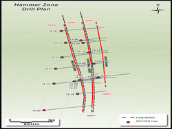
Hammer Zone - Plan View
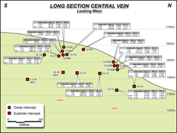
Hammer Zone -Long Section Central Vein
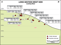
Hammer Zone - Long Section West Vein
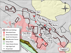
Regional Geology
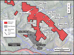
Silver Range Property and Infrastructure
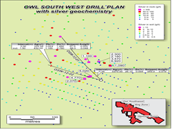
Owl Southwest Plan View
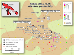
Rebel Zone Plan View
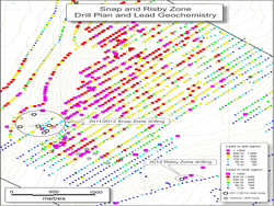
Snap and Risby Zones Lead Geochemistry
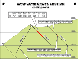
Snap Zone Cross Section 12-4,5,9,10
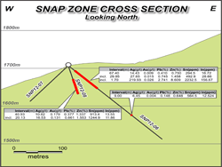
Snap Zone Cross Section 12-6,7,8
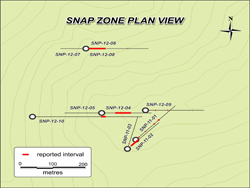
Snap Zone Plan View
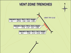
Vent Zone Trenches